Sludge Judging Has Its Limits: Why You Need Better Data Before Dredging
Sludge judging is a common way to check sludge levels in wastewater lagoons. It is simple, familiar and useful for routine operational monitoring.
The limitation is that a sludge judge measures one point at a time.
Taking readings at several locations tells you the sludge depth at those points. It does not necessarily tell you what is happening between them.
That becomes important when point measurements are used to estimate total sludge volume, determine remaining capacity or develop a dredging budget.
Sludge Does Not Accumulate Evenly
Sludge rarely forms a flat, consistent layer across the bottom of a lagoon.
It can build up around inlets, outlets, aeration equipment and other areas influenced by flow, weather and lagoon operations. One area may have very little accumulation while another may contain a significant sludge mound.
A sludge judge provides a measurement at a specific location. The problem is using that measurement to represent a much larger area.
The fewer measurements taken, the more interpolation is required between those points.
For routine monitoring, that may be acceptable. For dredging, budgeting, capacity calculations or treatment assessments, a more complete picture of the lagoon is needed.
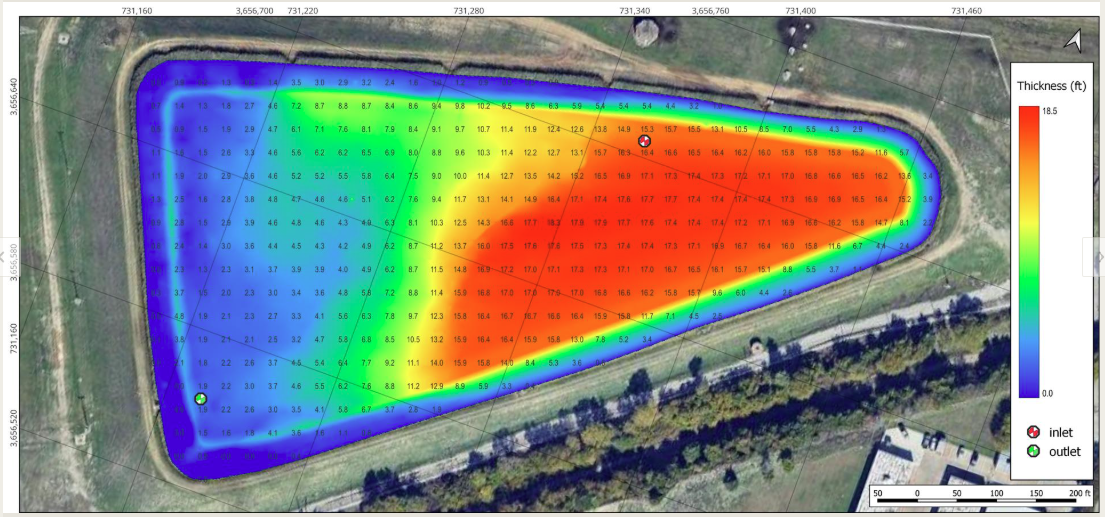
Sludge thickness map - not uniform throughout cell
Deep Water Makes Manual Sludge Judging More Difficult
Water depth creates another challenge with manual sludge judging.
In deeper sections of a lagoon, keeping a sludge judge or sampling device vertical becomes more difficult. If the device enters the water at an angle, drifts with wind or current, or moves away from the intended measurement point, the reading may not represent the true vertical sludge depth at that location.
A small angle at the surface can result in a greater horizontal offset by the time the device reaches the sludge blanket.
The characteristics of the sludge itself can also affect the reading. Denser sludge is often found deeper in the sludge layer, and some sludge judges can have difficulty capturing or retaining this heavier material. If that material is not properly represented in the sample, the reading may give an incomplete picture of the sludge layer.
Hydrasurvey uses a proprietary sludge sampling system designed to collect sludge at varying depths, including denser material deeper within the sludge layer. This allows us to collect samples from different elevations within the sludge profile and better understand the material present below the surface.
Operator technique also matters. Different operators may identify the sludge interface differently, lower the device at different rates or position the equipment differently. These factors can introduce additional variability into manual measurements.
This does not mean sludge judging has no value. It means the limitations of manual point measurements need to be understood, particularly in deeper lagoons or where sludge characteristics vary with depth.
The question is not whether a sludge judge works.
The question is whether a limited number of manual measurements provides enough information for the decision being made.
A Comprehensive Survey Measures the Lagoon as a System
A Hydrasurvey sludge survey is designed to determine the distribution and quantity of sludge throughout the lagoon.
Our survey will map the sludge blanket and identify where material has accumulated. Where required, we will also map the liner or bottom to establish the underlying lagoon geometry and determine sludge thickness.
Hydrasurvey uses survey-grade field methods including sonar-supported mapping, RTK GNSS positioning, sludge sampling, liner and bottom profiling, data processing and reporting. These methods are used together to develop a more complete picture of conditions below the water surface.
Instead of relying on a small number of individual readings to represent an entire lagoon, the survey provides mapped data for calculating sludge distribution and volume.
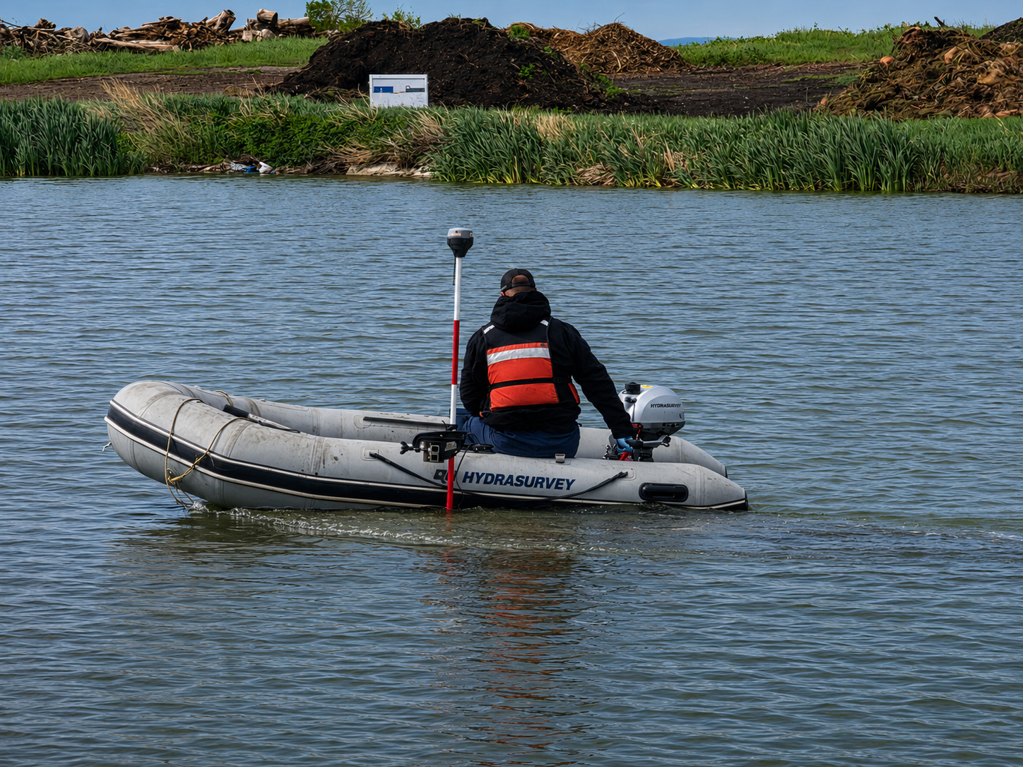
A comprehensive sludge survey collects measurements throughout the lagoon to map sludge distribution and calculate volume.
Why Accurate Volume Matters Before Dredging
Before you budget for dredging, you need to know how much material you are dealing with.
Sludge quantity is often one of the biggest unknowns at the beginning of a dredging project.
If the quantity is underestimated, the project may require more removal, dewatering, hauling, disposal, time and money than originally planned. If it is overestimated, the municipality may budget and tender for work that is not required.
Outdated surveys, limited sludge judging points and assumed quantities all introduce uncertainty before dredging begins.
A dredging contractor can only price the information provided.
An up-to-date sludge survey gives the municipality, its engineers and prospective contractors a measured quantity to work from. Hydrasurvey will map where sludge is located and calculate volume based on current survey measurements and project data.
That does not determine the final cost of dredging. Removal methods, sludge characteristics, dewatering, transportation, disposal requirements, site access and contractor rates all affect the final price.
What the survey does is address one of the most important unknowns:
How much material is actually there, and where is it located?
If you do not know the quantity, you do not really know the cost.
Know the Capacity You Actually Have
Sludge accumulation takes up space.
As sludge builds on the bottom of a lagoon, it reduces the volume available for wastewater. But total sludge volume is only part of the picture.
Where the sludge sits matters too.
Heavy accumulation around an inlet, outlet, aeration equipment or within a particular cell may have a different operational impact than the same volume distributed more evenly throughout the lagoon.
Our survey will map those differences.
Survey data will show sludge thickness and distribution and provide calculations for sludge volume and hydraulic capacity. Depending on the project scope, reporting will also include information such as dry tonnes, dredgeable quantities, liner or bottom elevations and area-specific accumulation.
Operators and engineers can then use current site data when reviewing capacity and planning future maintenance..
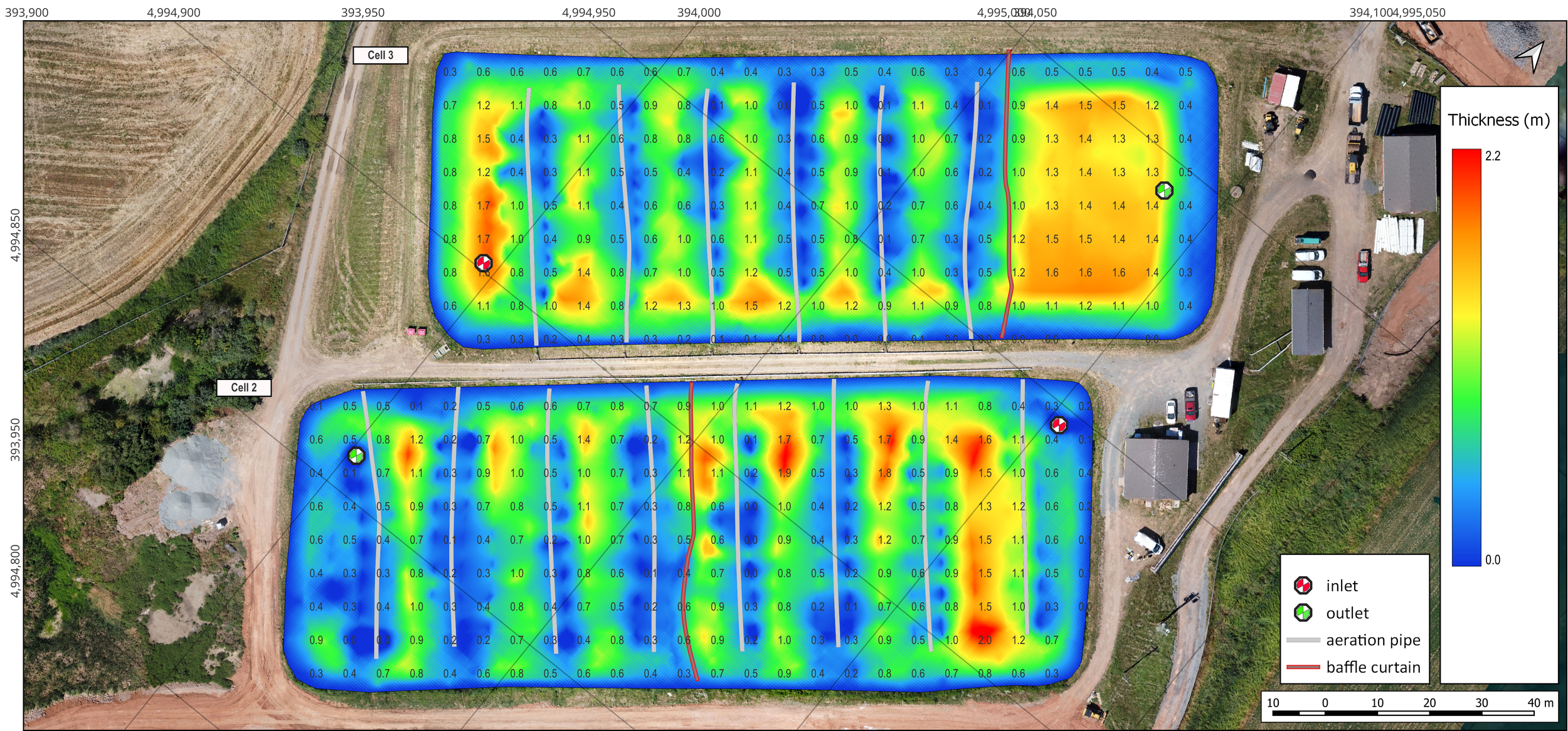
Sludge accumulation is not uniform. Aerators, flow patterns and lagoon curtains can influence where sludge settles and builds up.
Better Information Produces Better Dredging Budgets
Dredging costs are closely tied to quantities.
Contractors need to understand what they are being asked to remove. Municipalities need a reasonable basis for their budgets. Engineers need reliable information to develop scopes and tender documents.
A comprehensive sludge survey establishes a clearer measurement basis for all three.
Measured volumes and mapped accumulation give the project team better information for defining the work and give prospective contractors clearer quantities to price against.
This is particularly important when dredging must be planned through annual or multi-year capital budgets. Current sludge data helps municipalities determine the scale of the work before funding is committed.
It can also help answer an important question before a large dredging project is planned:
Does the entire lagoon require attention, or is the majority of the accumulation concentrated in specific areas?
Knowing the answer can significantly change how a project is scoped.
The Data Is Also Useful for Treatment Assessment
A lagoon does not need to be full of sludge before accumulation becomes important.
Where material accumulates can affect available hydraulic capacity and flow through the lagoon. Mapping will identify areas of heavy accumulation and differences between cells or sections of the lagoon.
That information gives operators and engineers another piece of the picture when reviewing lagoon conditions and treatment performance.
A sludge survey does not replace wastewater sampling, process testing, engineering analysis or operator knowledge.
It provides physical data about what is happening below the waterline that can be considered alongside those other sources of information.
Sludge Judging Still Has a Purpose
Sludge judging remains a useful operational tool.
For routine checks at established monitoring locations, operators can use it to track conditions and identify changes over time.
The limitation comes when a small number of point measurements are expected to answer much larger questions about total volume, distribution, hydraulic capacity and dredging quantities.
Those decisions require a different level of data.
Routine monitoring and comprehensive surveying serve different purposes. The method should match the decision being made.
What a Hydrasurvey Survey Will Provide
Our survey will establish the sludge surface, map its distribution, and calculate the amount of accumulated material based on the survey data collected.
Deliverables include:
Sludge thickness and depth maps
Sludge volume calculations
Liner or bottom elevation mapping
Hydraulic capacity information
Dry tonne calculations
Dredgeable volume calculations
Sludge sampling data
Area-specific accumulation
3D mapping and visualizations
Technical reporting for planning, budgeting, and tender preparation
These are the types of outputs Hydrasurvey uses to turn field measurements into practical information for municipalities, consultants, and contractors.
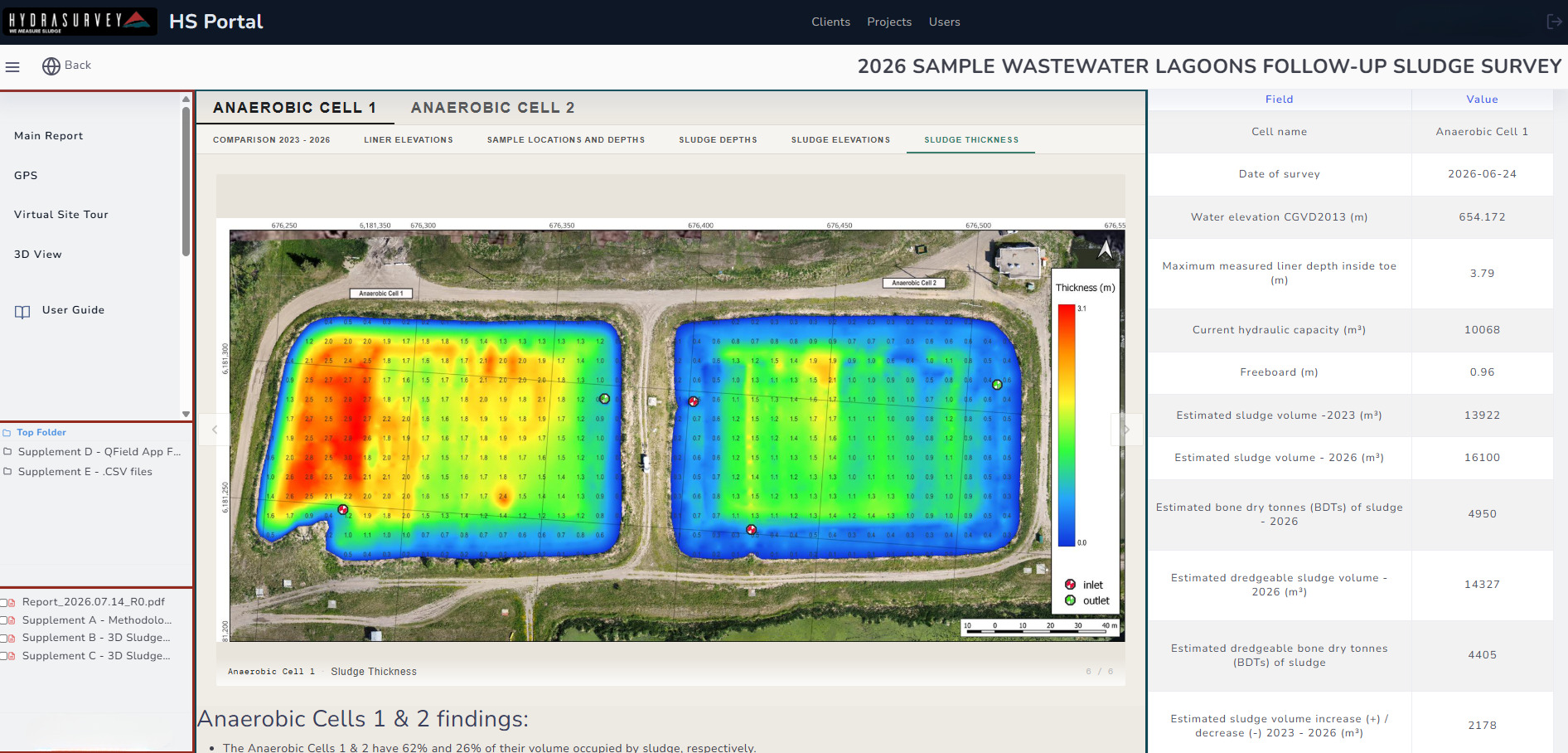
Hydrasurvey reporting turns field measurements into mapped quantities and practical information for planning, budgeting and dredging.
Before You Budget for Dredging, Know the Quantity
A sludge judge tells you what is happening at the point where you take the measurement.
A comprehensive sludge survey tells you what is happening across the lagoon.
That difference matters when a municipality is preparing a capital budget, developing a dredging scope, reviewing remaining capacity, or assessing lagoon operation.
Before committing money to dredging, establish how much sludge is actually there and where it is located.
Hydrasurvey measures sludge and sediment in engineered bodies of water across Canada and the United States.
Measure first. Plan second. Act with confidence.www.hydrasuvey.c