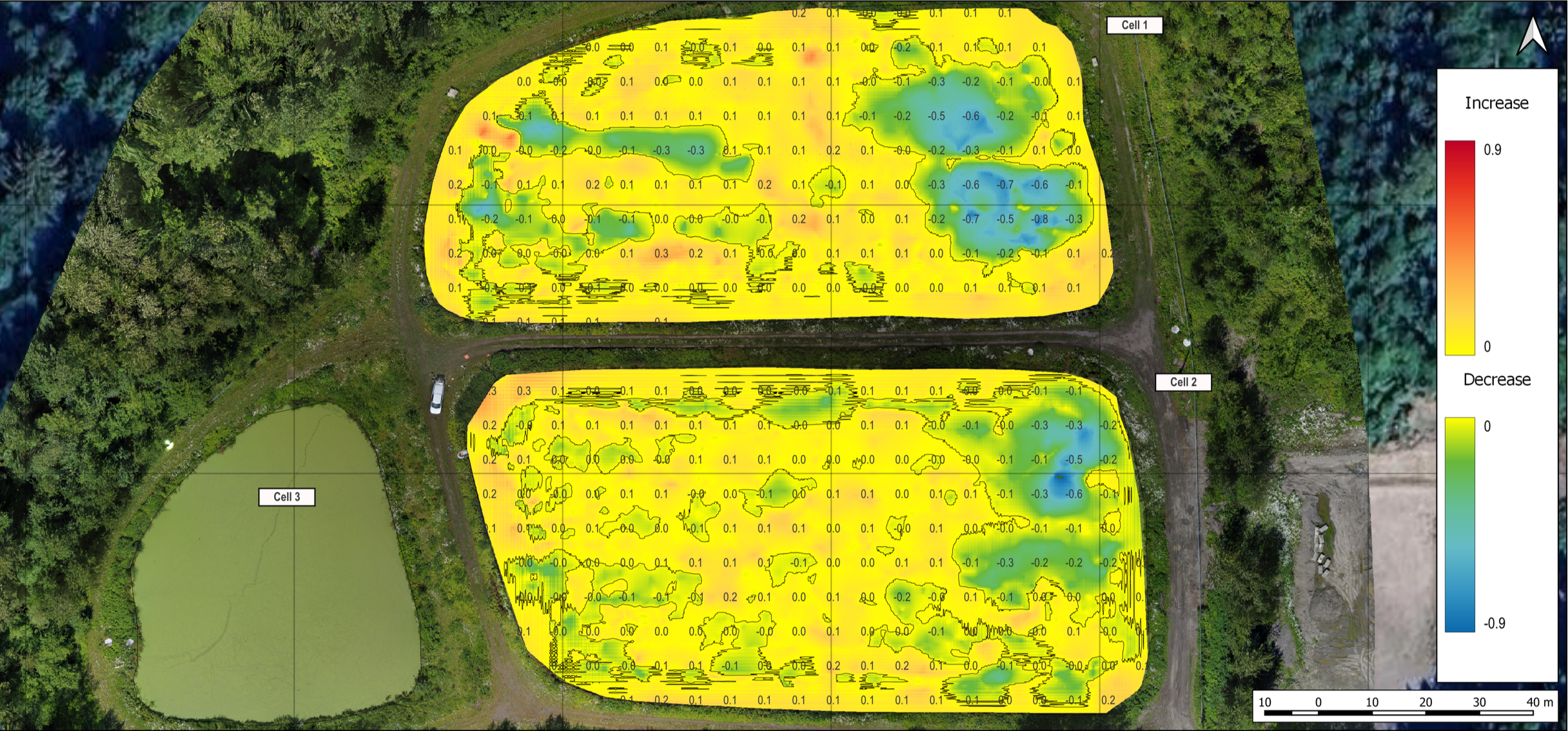
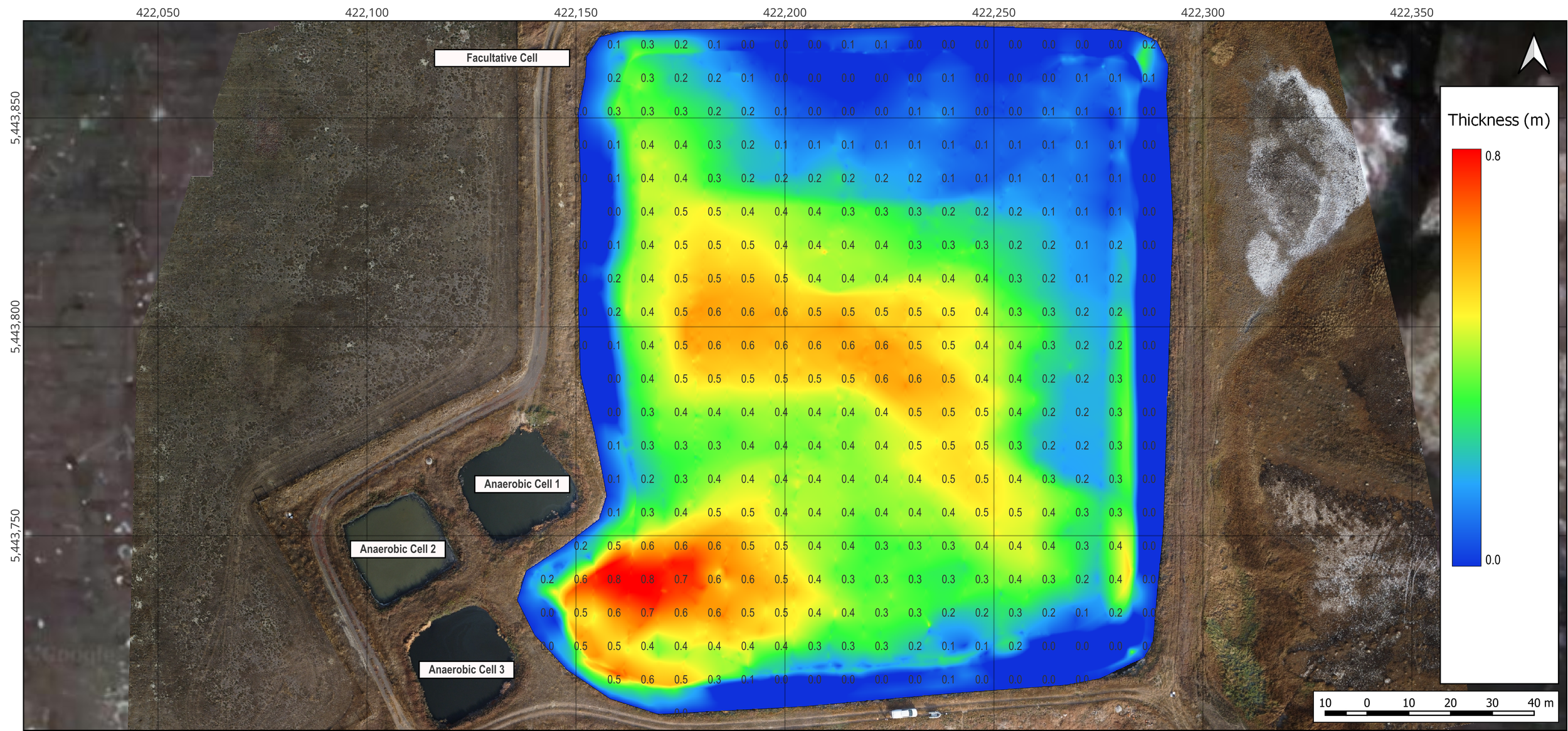
Hydrographic Sludge & Sediment Surveys

Stay informed and reduce project costs

Dredging and bioaugmentation cost more when you haven’t surveyed your lagoon or pond.

Without a survey, you start the project uninformed and risk overpaying or completing unnecessary work.

Benefits of a Lagoon Survey:

  • Competitive estimates - sludge surveys level the playing field for contractors to provide accurate estimates

  • Develop accurate budgets - more data means you know exactly what needs to be removed from your lagoon and when

  • Measure contractor and/or product performance - sludge surveys allow you to develop and execute a quality management plan for your sludge or sediment project

Follow these steps to get started.

Step 1: Contact us for a free estimate.

Step 2: We’ll complete your lagoon survey and provide you with a detailed survey report.

Step 3: Use your report to plan and budget for desludging or to assess the effectiveness of your bioaugmentation product.

The best part is we are third party. We don’t dredge or sell bioaugmentation products, so you can trust your survey provides unbiased results.

Find out how sludge and sediment surveys save you time and money:

  • Once you have measured and mapped your sludge you can obtain competitive quotes from dredging or bioaugmentation contractors. Without a survey you rely on contractor advice with no way to gauge if the work is necessary or a way to measure their performance.

  • Our sludge surveys provide you with an accurate sludge volume and the treatment capacity of your lagoon, which is a clear indicator of the need to dredge or not.

    We can also determine sludge volume in localized areas for spot dredging if you have a limited budget.

  • We determine in-situ sludge or sediment volumes and associated dry tonnage, which wastewater contractors use to estimate costs for desludging or bioaugmentation.

    You will have data that levels the playing field for contractors so you will receive the lowest cost to complete the work.

  • We monitor dredge contractor performance and have experience communicating our results with all parties. Our surveys help ensure contractors are able to dredge the entire lagoon.

  • We sample and test the sludge in an accredited lab to identify your disposal or reuse options.

  • We evaluate if your bioaugmentation product is effective by completing surveys at different time intervals then we compare any changes.

  • We calculate the rate of sludge or sediment accumulation, by extrapolating this rate, we determine when your lagoon or pond will be full. This provides you with a timeline for planning future projects.

Sediment Surveys


Determine what’s in your stormwater and raw water ponds.

Stormwater retention ponds are built in cities and neighbourhoods to control excess groundwater and runoff. These ponds play an important role in emergency flood management and planning. To keep these ponds functional you need to know what their storage capacity is and if there are any infrastructure challenges. This information is included in our hydrographic sediment surveys. By completing a survey you will learn the current sediment volume and hydraulic capacity of each pond, the sediment composition and if there are any infrastructure problems hidden under the water. In our reports we also include 3D sediment maps overlaid onto drone images for use in planning and presenting.

Stormwater retention pond sludge survey
Stormwater pond sludge survey in Alberta
3D Sludge map of a stormwater retention pond
3D Sludge thickness map of a storm water retention pond

Virtual Site Tours

Now included with every Comprehensive Sludge Survey Report

  • Is it difficult for you to get out to a lagoon or pond site? You might manage a lagoon project remotely, be bidding a lagoon project in a town that is too far away for field visit or just not have the time between watermain breaks to inspect your lagoon in good detail. A Virtual Site Tour brings you to the lagoon, from the comfort of your office. 

  • Site tours provide either an aerial map or several panoramic photos of the site at the time of survey with inset photos of important findings. This greatly assists in identifying mechanical or infrastructure damage not easily seen from one location at the lagoon or for clients who have limited access to site and are managing projects remotely. They are also a fantastic addition for a group presentation or meeting with council. We are thrilled that this new feature has been positive and continues to solve client challenges.

  • Check out this Virtual Site Tour as an example of what to expect! 

Virtual Site Tour from a Wastewater Lagoon Sludge Survey

Get the best data.

We use advanced technologies and safe work practices to provide precise unbiased data.


Our reports include:

  • Sludge blanket distribution thickness map for dredging

    Sludge Blanket Thickness Maps

    Sludge blanket thickness maps provide a clear visual of where your sludge buildup occurs and how it’s distributed across the bottom of your lagoon or pond. These maps are an excellent visual when dredging, they display what progress has been completed.

  • 3D sludge map 3D sediment maps

    3D Sludge and Sediment Maps

    3D sludge / sediment maps are provided to display your lagoon or ponds sludge characteristics. They can be provided to contractors for improved efficiency.

  • Liner measurements using a GNSS mounted survey rod taken

    GNSS Liner Maps

    We manually measure the liner using a GNSS mounted survey rod to provide you with liner elevation maps. This also increases the accuracy when quantifying sludge and sediment volumes.

  • Sludge sampling using a Eckman sludge sampler

    Sludge & Sediment Samples

    We collect and test, at an accredited lab, sludge or sediment samples to determine composition. Composition is required to calculate sludge / sediment volume and provide you with dredging disposal options.

  • RTK fixed survey GNSS

    RTK GNSS Positioning

    Using RTK GNSS positioning to map your sludge or sediment blanket provides you to the most accurate data.